
IAS Students Map Bothell Communities
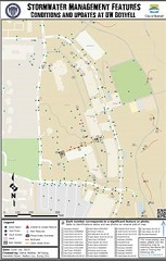
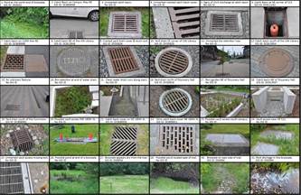
IAS Students in Jin-Kyu Jung’s BIS352 “Mapping Communities” class created a number of maps for the City of Bothell in Spring 2015. “Mapping Communities” is designed as a Community-Based Learning and Research (CBLR) course from its inception. It provides a unique opportunity for students to critically examine the constructions of both “community” and “mapping.” The larger goal of constructing community maps is to understand a community’s needs, and to connect to local communities through the mapping process. At the end of the course, students provided the resulting maps to the communities, and shared reflections and assessment.
Two students, Jef Song and Sung Chu produced a great video of the work done in this course:
Students learned to apply knowledge of new geospatial web and technologies throughout the community mapping process,with particular focus on geovisualization with Google Maps and Google Earth.
Spring 2015 projects include: “Mapping Storm Water Management,” “Wetlands,” “Mapping University Engagement in Downtown Bothell,” “Mapping Walking and Biking Trails around UW-Bothell and Bothell downtown,” and “Mapping Nature and Wildlife in North Creek and Woodinville.” Students created both online as well as print maps.
Our community partners in the City of Bothell (Janet Geer, Eric Haskins, and Daryn Brown from the City and Diane Petrula, a local resident) provided tremendous support throughout the project.